Contents
Index
Cleanup Job
Cleanup will carry out the following tasks:
Mean Close Points
Tick this to mean any close points in the job
Mean Close Point Tolerance
This is the minimum distance used to determine 'close points'.
If any two points are found to be closer than this test distance and there is no line joining them,
the coordinates will be set at the mean value of the two and the second point deleted.
Erase Unused Points
Any point which is not on a parcel corner or a text string will be deleted
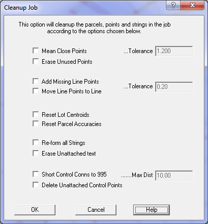
Add Missing Line Points
Any point which is within the tolerance distance from a parcel line will be set up as line point
in that parcel. If the line point already exists, it will not be duplicated.
Set the maximum offset distance in the close point/line point tolerance box.
Line Point Tolerance
This is the maximum distance to be used for line point creation.
Move Line Points to Line
This will move every line point back on to the line that it is referred to.
Set the maximum shift tolerance.
Reset Lot Centroids
This will recompute the location of the lot number for each parcel.
Reset Parcel Accuracies
This option will compute the parcel accuracy based on the date of survey and set
that parcel accuracy in the parcel. All parcels will be computed in the same way.
This option will override any manually entered parcel accuracy values.
Re-form all Strings
This will first erase all the strings in the job.
Be careful as this option will erase any string you entered by hand in GeoSurvey, if any.
The program will then create srings from the parcels.
Erase Unattached Text
Any Text element which is not a parcel name will be erased.
Short Control Connections to 995.
Any connection lines which are shorter then the tolerance distance and are connected
to a control point will be set to a line type 995.
Max Dist
The tolerance distance for 995 connections to control.
Delete Unattached Control Points
Deletes any control points which are not attached to points in the job.